
Africa has significant potential in Space that needs to be exploited to contribute to the continent’s socio-economic development. The African Union Commission has been spearheading efforts to tap into these opportunities to catalyse the livelihoods of people in the continent. By an edict of the Heads of State and Government of the African Union, the Commission initiated the African Space Policy and Strategy to facilitate the coordination and regulation of Africa’s Space activities.
The Global Monitoring for Environment and Security and Africa (GMES and Africa) is a continental initiative designed to support and enable the implementation of the African Space Policy and Strategy, by way of addressing the needs of African countries in terms of access to and utilisation of Earth Observation (EO) data for the implementation of sustainable development policies on the continent. It supports the management of the environment and natural resources, as well as monitoring of humanitarian operations in Africa. The programme is jointly funded by the European Union to the tune of 30 million Euros.
Part of what the first phase of GMES and Africa focuses on is Water & Natural Resources. The programme is implemented through a competitive Call process which awards grants to consortia of institutions in the various regions of Africa, operating projects that deal with water and natural resources.
In this series, we highlight each of the agencies working towards actualising the objectives of GMES & Africa on Water & Natural Resources, with emphasis on the problems they are solving and how they are solving them.


Centre de Suivi Ecologique (CSE)
The GMES and Africa consortium led by the Centre de Suivi Ecologique (CSE) of Senegal covers eight West African countries, including Burkina-Faso, Côte d’Ivoire, The Gambia, Ghana, Guinea, Mali, Niger and Senegal.
CSE specialises in Wetland Monitoring and Assessment and provides solutions like developing a sustainable management plan of wetlands. This includes the dissemination of information on three themes related to wetlands: water (wetland inventory, water body dynamics and water quality), vegetation (invasive aquatic plants, mangrove monitoring, land use and land cover mapping), and soil (soil moisture and soil salinisation).
CSE has made successful institutional arrangements and organised restitution workshops in the countries of the consortium, and also made documentary reviews and characterisation studies of the selected wetland sites. It has been able to strengthen capacities of consortium members in terms of field work and consultation with the local population.
Wetlands are highly productive and biologically diverse ecosystems that contribute significantly to livelihood and economic development. Effective assessment and monitoring mechanisms, such as the ones initiated by CSE, can inform policy and decision making to promote the sustainable management of wetlands. This will have a direct positive impact on the quality of life of communities whose activities contribute to degrading these ecosystems.
CSE’s consortium partners include : Centre d’Observation, de Surveillance et d’Information Environnementales; Centre de Télédétection et de Service d’Information Géographique; Centre Universitaire de Recherche et d’Application en Télédétection, Département des Parcs et de la Gestion de la Faune; Direction de la Faune, de la Chasse et des Aires Protégées, and Direction National des Eaux des Forets Institut Géographique du Burkina.
Southern African Development Community-Climate Services Centre (SADC-CSC)
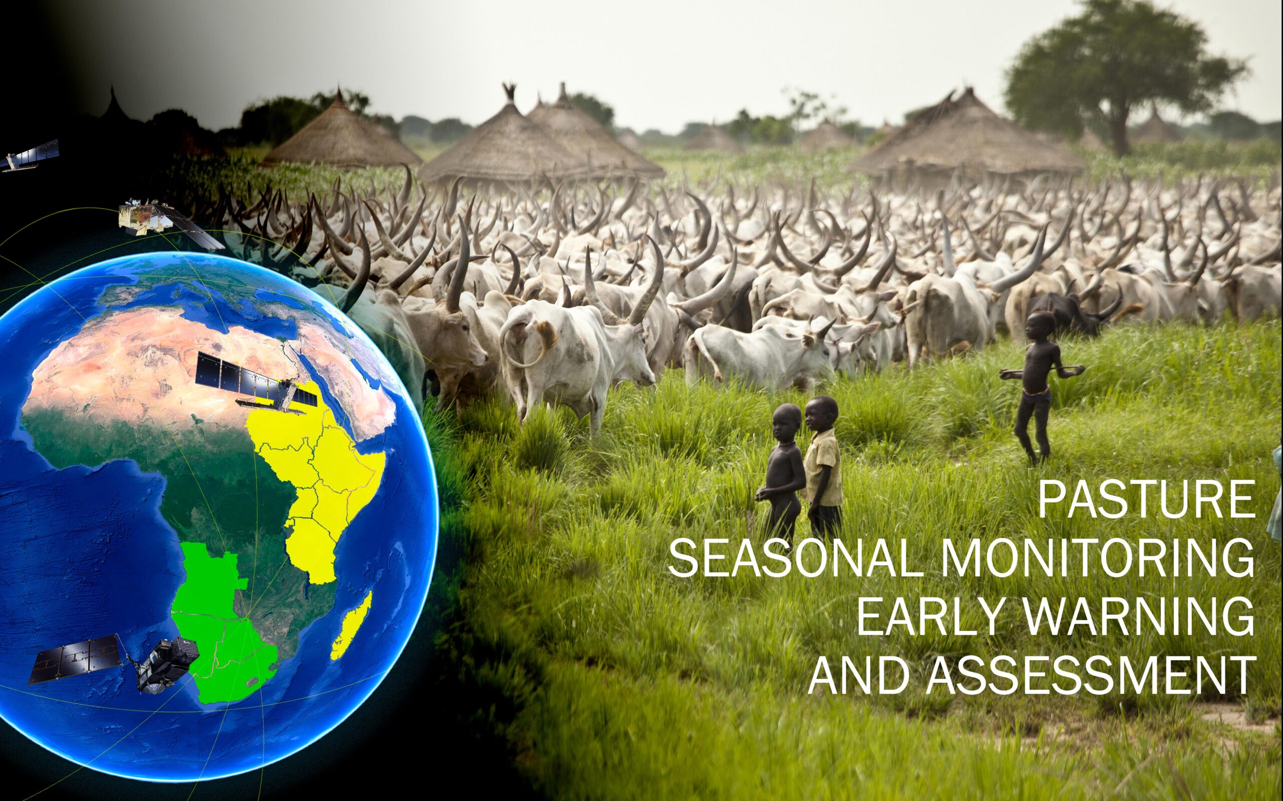
The Southern African Development Community-Climate Services Centre (SADC-CSC) is the lead institution for GMES and Africa’s consortium in Southern Africa, addressing riverine flood monitoring and assessment, agriculture seasonal monitoring, early warning and assessment, as well as rangeland seasonal monitoring, early warning and assessment. SADC-CSC also attends to wildfire seasonal monitoring, as well as early warning and assessment.
Consortium partners include Botswana University of Agriculture and Natural Resources; University of Zimbabwe, South African National Space Agency, and the National Remote Sensing Centre of Zambia
SADC-CSC develops early Warning Systems on flood monitoring software using Flood Rating tables and discharge graphs based on current and forecast rainfall. It generates maps for grazing capacity, rangeland conditions, crop status as well as forecast tables and graphs. SADC-CSC provides alerts when an active wildfire is detected and notifies users through their preferred modes of communication including SMS and email. SADC-CSC has prepared the ground for the implementation of the four proposed services by refurbishing stations to ensure access to EO data, developing online training platforms and renewing collaborative frameworks with partner universities.
The consortium’s ultimate aim is to have other programmes and projects use the data derived from GMES and Africa, and ensure that thirty-five EUMETCAST Stations (PUMA 2015, MESA and wildfire stations) in the participating countries are operational at end of the GMES and Africa initiative. It further aims to have universities develop courses or curricula based on EO applications, and engage and commit policy makers, administrators, the private sector, scientists and civil society at all levels in the GMES & Africa initiative.
Centre for Space Science and Technology Education (CSSTE)
The Centre for Space Science and Technology Education (CSSTE) is based in Nigeria, and leads the GMES and Africa consortium in West Africa, comprising: Centre Universitaire de Recherche et d’Application en Télédétection, Université Félix Houphouët-Boigny in Côte d Ivoire; Institut Supérieur d’ Etudes Spatiales et Télécommunications of Burkina Faso, Institut National de l’ Eau du Bénin; University of Ghana’s Department of Earth Science, Volta Basin Authority; and Water Research Institute, Council for Scientific and Industrial Research of Ghana.
CSSTE is specialised in riverine flood monitoring and assessment and addresses the lack of capacity of disaster management organisations in terms of logistics and knowledge of flood events. The centre also tackles weaknesses of existing forecasting systems, setbacks in the development and use of flood hazard maps for managing floods in West Africa, and challenges faced by disaster management institutions and other organisations in harnessing the potential of EO technologies.
To resolve the issues highlighted above, CSSTE has developed a regional scale flood event database for the five countries it covers, and uses image acquisition, processing and analysis systems to map flood extent during or immediately after flood events. The consortium operates a flood forecasting system to provide near-real time information on impending floods and a damage assessment module that will assist in evaluating the degree of damage after flood events. Strengthening the capacities of disaster management, meteorological, hydrological and mapping organisations is among its key priorities.
In preparation for the tasks ahead, CSSTE has acquired RS data and developed geo-data bases for classification and flood modelling. The Hydrologic Engineering Centre’s river analysis system has been prepared for flood modelling. Training and a robust media as well as an outreach campaign have been part of the consortium’s delivery strategy.
IGAD Climate Prediction and Application Centre (ICPAC)
The IGAD Climate Prediction and Application Centre (ICPAC) covers East Africa’s IGAD region, leading a consortium of partners comprising Kenyan Wildfire Service, Tanzania Forest Service Agency, Sudan’s Ministry of Animal Resources and Mekerere University.
ICPAC addresses natural habitat conservation, forest degradation and deforestation; agricultural seasonal monitoring, early warning and assessment; rangeland seasonal monitoring, early warning and assessment. It provides wildlife and conservation authorities with maps and predictive information on human-wildlife conflicts, as well as forage availability and distribution.
ICPAC is well positioned to deliver its mandate with most of the required technical infrastructure, training and communication needs already in place to support the long term management of natural resources in East Africa’s IGAD zone. The consortium is providing opportunities for research, higher education and training. It has already sponsored two Masters Degree students undergoing relevant programmes in natural resource management, and trained sixty persons at the national level.
Ultimately, ICPAC will contribute to improving the livelihoods of people living around protected areas and forests by avoiding conflicts with wildlife. Ensuring the maintenance of sustainable natural resources which are a source of food, heating and refuge will also advance the quality of life of forest populations. With ICPAC’s outreach and communication, farmers get informed about pests and diseases, when to crop, when to irrigate and when to harvest. The consortium sensitises pastoralists about the location of water points, information crucial for food security and for human and animal survival.
Regional Center for Mapping of Resources for Development (RCMRD)
The Regional Center for Mapping of Resources for Development (RCMRD), is the lead institution for one of GMES and Africa’s consortia in the Eastern Africa region. Based in Kenya, the consortium addresses land degradation, wetlands monitoring and assessment and agro-ecological zonings.
RCMRD provides atlases, maps, quarterly bulletins, reports, training materials, digital databases, brochures and guidelines that provide information relevant to decision-making, in order to address the problems related to land degradation, wetland monitoring and assessment, as well as agro-ecological zonings. The consortium’s target beneficiaries include: communities and individuals dealing with natural resources management at all levels, farmers, nomadic pastoralists and rural communities, civil services, local authorities, city councils, parks and natural reserves administrations.
RCMRD has succeeded in assigning a Technical Working Group to the project and organised a workshop for all stakeholders to discuss products and services. It has also conducted needs assessments in partner institutions, whilst identifying relevant services and products that will be made available to the users.
RCMRD’s partners include the Ethiopian Mapping Agency, Makerere University, Mauritius’ Ministry of Lands, and Rwanda’s Water and Forestry Authority, The consortium expects to help inform and equip ministries and institutions with tools that combat land degradation, thereby addressing a major problem confronting some populations. Wetlands are a source of life, especially for food, hunting, fishing, etc. Therefore, RCMRD’s efforts at wetlands conservation have a direct impact on the quality of life of people living around wetlands.
Agence Gabonaise d’Etudes et d’Observations Spatiales (AGEOS)
The Agence Gabonaise d’Etudes et d’Observations Spatiales (AGEOS), is the national space agency of Gabon and leads GMES and Africa’s Central African consortium, which comprises Commission des Forêts d’Afrique Centrale (COMIFAC) of Cameroon, Office Burundais pour la Protection de l’Environnement, Institut National pour l’Environnement et la Conservation de la Nature (INCOMA) of Equatorial Guinea., and Université de Moundou of Chad. AGEOS is working on forest resource estimation and monitoring, access to EO observation data and dissemination, and the dissemination of derived products, user engagement and ownership of developed products and services.
AGEOS offers support in the acquisition of new systems, connection to EO data and product servers, and produces key data and information on forests. It continually monitors forest cover, forest condition and biomass as well as wetlands of flooded areas, and logging and mining activities. It also actively monitors agricultural activities at a rural level and on an industrial scale, whilst providing training, capacity building, and communication services.
AGEOS has succeeded in the characterisation of optical, radar and ground data and the challenges to acquire and process them, as well as distribution of products with regards to existing infrastructure. All members of the consortium have been equipped with data processing machines. The agency continues to aim at responding to the needs of sub-regional organisations such as ECCAS, CEMAC and COMIFAC in terms of the environment and natural resource management, with a view to achieving the Sustainable Development Goals and the African Union’s Agenda 2063. It will further drive at producing relevant baseline data and indicators, organising and disseminating data as well as products and services, extending and appropriating products and services , and training and capacity building in the use of earth observation data.
Commission Internationale du Bassin Congo-Oubangui-Sangha (CICOS)
The Commission Internationale du Bassin Congo-Oubangui-Sangha (CICOS), based in the Democratic Republic of Congo, leads institutions forming a GMES and Africa consortium in Central Africa. CICOS is partnering with Groupement d’Interet Economique pour le Service Commun d’Entretien des Voies Navigables du Congo et de la Republique Centrafricaine, Université de Kinshasa, Observatoire Satellital des Forets d’Afrique Centrale, Commission du Bassin de Lac Tchad, and Centre de Recherche Hydrologiques of Cameroon.
The consortium tackles water resource management by delivering user customised information on navigation, meteorological, hydrological, hydropower and drinking water production, agro-pastoral services, forest management and protected areas, among others. It provides tailor-made solutions through the consolidation and improvement of existing observation systems, including in-situ and satellite data gathering systems, and by estimating real (or near real) time watershed levels and water availability. CICOS develops and improves processing chains, alert systems and targeted applications and formulates training curricula for regional experts. It is deeply involved in awareness-raising for decision-makers.
CICOS has gained grounds in the maintenance and recovery of related EO stations, and has purchased and installed some equipment. It has created and upgraded its databases, defined methodological approaches, and issued maps on flooded areas around forests, natural habitats and bush fires. The consortium has already launched digitisation and development navigation maps and gauged watercourse campaigns. It has also started the production of maps relating to land use and evolution of natural habitats, and is currently developing mobile applications.
CICOS targets monitoring of water resources with particular focus on water levels for inland navigation, monitoring of the water balance of the sub-basins of the Central Africa region, and monitoring of the dynamics of flooded areas under the central basin. It works towards improved decision-making processes, more effective and harmonised policy implementation, and trans-boundary collaboration. The consortium aims to advance collective security. For example, it wants to enable freshwater sailors and companies to anticipate difficulties in certain shallow draught areas, mitigate the related human risks, and upgrade the security of boats and passengers. Broadly, it aims to facilitate and develop the navigation business.

Observatoire du Sahara et du Sahel (OSS)
The Observatoire du Sahara et du Sahel (OSS), operates in the field of water abstraction surveillance, monitoring and assessment in irrigated areas, land degradation monitoring and assessment & agriculture seasonal monitoring, early warning and assessment. It is based in Tunisia, and leads the GMES and Africa consortium in North Africa, comprising : Centre Regional Africain des Sciences et technologies de l ‘Espace en Langue Francaise, Centre Regional de Teledetection des Etats d’Afrique du Nord ; Agence Spatiale Algerienne, Centre National de la Cartographie de la Teledetection; Centre Royal de Teledetection Spatiale, Desert Research Centre; Libyan Centre for Remote Sensing and Space Science, and Unite de Recherche de Mauritanie.
To provide solutions to the issues it is addressing, OSS is involved in mapping of irrigated areas, withdrawn waters and areas vulnerable to desertification. It also develops geo-portal and interactive visualisation interfaces. The consortium provides information extracted from Earth Observation to decision makers and synthesises reports, graphs, and thematic analysis. It also formulates technical reports and capacity building modules
OSS has created a clear common pathway for understanding of the project’s vision and services, and established an institutional framework for collaboration with its partners. It has performed analysis of end-user needs and diagnosis of existing and identified pilot areas for service implementation.
North Africa is an arid sub-region and faces three major challenges: aridity, recurrent drought and desertification. In addition, 70 % of water abstraction in the region is for irrigation. Through OSS and its consortium partners, populations will be sensitized about effective water management. The agriculture and land degradation services provided by OSS will improve the quality of life of communities by minimizing importation of food, reaching higher levels of food security, and having more land for agriculture by combating land degradation.
Southern African Science Service Centre for Climate Change and Adaptive Land Management (SASSCAL)
The objective of the Southern African Science Service Centre for Climate Change and Adaptive Land Management (SASSCAL) is to mitigate ineffective or constrained wetland assessment and monitoring. SASSCAL utilises an integrated web-based platform to analyse and integrate information from various sources including EO and in-situ, assess wetlands conditions, and provide wetland information services to target groups and end-users.
To position itself for effective service delivery, SASSCAL has identified and delineated wetland areas in the region, and reviewed different satellite-based EO data, as well as the potential and limitations of said data. It has also reviewed existing free open source software and tools and started integrating Sentinel and LandSat images across the trans-frontier river basins. The training needs of stakeholders have also been assessed and various consortia members have received specialized trainings from SASSCAL. Beneficiaries include ICT staff working on infrastructure development and implementation as well as four students.
SASSCAL aims to achieve include a Wetland Monitoring and Assessment Platform for Trans-boundary Basins in the southern African region that could deliver data, maps, information, and statistics. The platform will also indicate trends on wetland mapping of floodplains, swamps, marshes, and other surface water bodies, and equally provide information on water cycle regimes, vegetation dynamics and productivity. As part of its mandate to contribute to relevant research, training and information sharing, the consortium seeks to support gender-balanced postgraduate studentships and public awareness campaigns.
SASSCAL’s interventions will impact its beneficiaries with tools to mitigate and relieve pressures on resource, in concert with various natural phenomena. This will support the sustainable management of water and other natural resources, and help communities adapt and improve unsustainable agricultural practices. They will be able to implement better planning of land cover and land use, and also fight against invasive species infestation, and climate change impact.
The SASSCAL consortium covers river basins of the SADC region, and institutional members include: University of Botswana, South African National Space Agency, South Africa National Remote Sensing Centre, Midlands State University, University of Zambia and University of Western Cape.
Click here to read the second part of this article.


